Pinagbuhatan and Bitukang Manok -- What's in a Name?
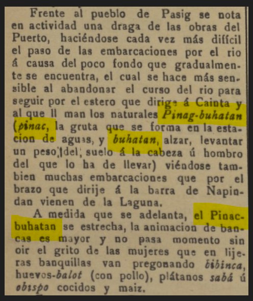
Bitukang Manok--It is often romanticized now as the river of the revolution in Pasig.The waterway that Bonifacio and his close associates traversed on the way to Pasig for an assembly, where the decision to raise arms was reached in May 1896. It is now being referred to as Bitukang Manok yet nowhere in the early memoirs and journals of the revolution was it ever called as such. What's in a name? Meanwhile, Bitukang Manok traverse first to what many believe as its boca--the mouth, its beginning . For this reason, does the place fits its name in Tagalog -- Pinagbuhatan? What's in a name?
PINAGBUHATAN
In the mid-1990s, eminent Pasig historian Dr. Luciano PR Santiago hinted at the possibility that the first mission in Pasig founded by the Spaniards in 1572 could actually be Pinagbuhatan. He suggested that the men of Legazpi reached the area on the feast day of San Sebastian, January 20, thereby establishing the foundation of the church and the new mission under the name and protection of the said saint. However, the Spaniards later concluded that it was not an ideal central location. Concerns were also raised when it was learned that the area of Pinagbuhatan suffered from periodic inundation.
In 1573, almost a year after its supposed founding, the mission was transferred to the area called Malinao-- Pinagbuhatan was relegated to being just another "visita" of Pasig. Dr. Santiago then added that people would often refer to the place as "pinagbuhatan ng simbahan," hence the origin of Pinagbuhatan's name. However, he also admitted that all of these narratives are merely suggestive on his part and should not be taken as historical facts until documents would back his claim.
I am in the opinion that the topography of the area seems to favor the suggestive position of the barrio and its relation and location to the flowing river as the foremost reason why it was named as such. Would toponym and the dynamism of Tagalog language render me correct?-- I still would have to wait. But the boca as I understand is the beginning of the anatomical gut. Would it be applicable to that of a flowing river -- Bitukang Manok?
BITUKANG MANOK
Early maps of Pasig in the Spanish Period named the waterway as "Rio de Pasig", its mouth connected to the great Pasig River leads to Sitio Gahit (Pinagbuhatan) or the boca, heading towards the other sitios (districts). First to sitio "Ilaya" then "Ibaba" and the sitio in the other bank called "Malasaga", until it reaches "Wakas". It is in this area that the waterway enters another barrio called Palatiw. From there it connects to the next barrios and to other canals and creeks like the "Sapang Liwanag". But the main flow then heads towards the center of Pasig, to the old "Parian". For this reason, it is also often referred to as "Parian Creek". Even in cadastral mappings during the American Period, one could see this labeling.
One Spanish map commissioned in the 1820s had an interesting name labeled on the river ― "Rio de Pinagbujatan (Pinagbuhatan), obviously, as a reference to the place where the supposed mouth begins--Right away the connection. But in Barangay Pinagbuhatan the waterway is simply called "sapa", some also call it now as "dike".
 |
| " Rio de Pinagbujatan" - Section taken from "Plano Topográfico de Manila y sus Contornos" Cuerpo de Ingenieros/ Manila 1823. Biblioteca Virtual de Defensa (Spain) |
It seems to be that the term "Bitukang Manok" is relatively a recent development and it is mostly related to the commemoration of the events of 1896. Yet memoirs of known figures in the revolution like that of Gen.Santiago Alvarez have never mentioned it as "Bitukang Manok". Emilio Aguinaldo in his memoir of the revolution even had a mixed up, saying that the Katipunan assembly was held in Pateros. Interestingly, he mentioned the said meeting took place in the waterway, "Gahit River". Nick Joaquin followed the Aguinaldo account, writing in his narratives about the event: "But when they reached Pateros they tied the bancas together and held their meeting in the middle of the Gahit River, with Bonifacio presiding from the center boat".
"Gahit" is not a river, as I mentioned earlier. It is a small district that still exists up to this day and is also known now as Purok Jasmin in Pinagbuhatan Pasig.
I searched in archives and documents to prove that Bitukang Manok is indeed an old term. Our labors gifted us with some proof. It is indeed an old name. But the underlaying fact still bogged me -- The locals hardly call it as such. is there another Bitukang Manok in the outskirts or even in the towns outside of Pasig?
What's in a name? The term Bitukang Manok could also be a description of waterways connected to many canals and tributaries, meandering like that of animal innards, having the character of an old river that quietly flows. There is a long estero in Paranaque that flows out of Manila Bay which is called "Tripa de Gallina" -- The term fits the translation Bitukang Manok.
Somehow I cannot help but ask why the term "Bitukang Manok" reached the local and then the national narratives, almost a quasi-mythical name when mentioned with the 1896 Revolution? Who put it into our awareness?


.png)


Comments
Post a Comment